Have any Questions?
+ 92 51-4840137
Get in Touch
Have any Questions?+ 92 51-4840137
Follow us

Buraq Integrated Solutions (PVT) LTD

Founded in 2000, Buraq Integrated Solutions (BIS) has successfully executed multidisciplinary projects across Bangladesh, Maldives, Singapore, Thailand, Indonesia, Turkey, UAE, Bahrain, KSA, Australia, and the USA.

Contact Us

Location
HQ: Buraq Integrated Solutions 11-D 6th Road, Satellite Town, Rawalpindi, Pakistan.

STZ: 1st Floor, Alpha-18, NASTP, Old Airport Road, Rawalpindi, Pakistan.

AUS: Buraq Integrated Solutions Unit 55, 10 Yato Road, Prestons NSW 2170, Australia.
Phone
+92 51-4840137
+92 333-5132514
+92 300 5121896
+61 300 786 599
Email
info@buraq.com

Road Weather Information Systems

Solutions

Road Weather Information Systems (RWIS) 

More than 1.4 million highway crashes occur each year in the U.S. due to adverse weather and road conditions. While weather cannot be controlled, its impact can be monitored and managed through Road Weather Information Systems (RWIS). These systems help transportation agencies make informed decisions such as applying anti-icing chemicals, adjusting speed limits, or temporarily closing hazardous areas.

How RWIS Works 

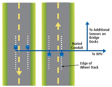
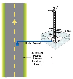
RWIS relies on Environmental Sensor Stations (ESS) placed along highways to collect real-time weather and roadway information. These stations form the foundation of the system and transmit data to a central location where it is used for road maintenance and traffic management.

A typical ESS includes sensors for air temperature, humidity, wind speed and direction, precipitation type and intensity, pavement temperature, freeze point, and chemical concentration. Video cameras are often added to help operators visually confirm conditions. Some stations also monitor subsurface temperatures, visibility, water levels, and solar radiation

Capabilities and Limitations  

RWIS operates year-round to monitor a wide range of atmospheric and pavement conditions, from icy roads and strong winds to flooding or rapid temperature changes. The data helps agencies anticipate hazards and respond quickly.

However, certain conditions, such as snowpack depth or thunderstorms, still lack reliable automated sensing technologies. Sun glare and tornado observations also remain beyond the capability of current ESS instruments.

Uses and Benefits  

ESS data are essential for monitoring fast-changing road and weather conditions. By supplying real-time information on storms, pavement temperature, moisture, and visibility, these systems help transportation agencies maintain safer driving conditions and keep traffic moving during adverse weather.

Traffic managers, emergency response teams, and maintenance crews rely on ESS insights to provide accurate traveler information, coordinate emergency actions, and plan activities such as de-icing and snow removal. This improves safety, enhances mobility, and supports more efficient transportation operations.

Power and Communications Considerations 

Power and communication planning begins with understanding data requirements. Commercial power is usually the most reliable, while solar or wind can support low-power sites. In some locations, ESS equipment can be placed near existing ITS devices to share power and reduce costs, with backup systems added for critical sites.

Communication options include telephone or copper lines, cellular networks, fiber optic cable, wireless radio or microwave links, and satellite. The selection depends on bandwidth needs—low-data sites can use wireless or telephone connections, while high-data systems with video typically require fiber or other wired solutions.

This diagram shows the typical siting for pavement sensors, near the edge of the wheel track.

The diagram shows the desired tower location relative to a roadway.

Site Layout, Aesthetics, and Security 

Proper siting of the tower and pavement sensors is essential for accurate data collection. Maintaining adequate distance from obstructions may make the sensor tower more visually prominent, so early discussions with nearby communities can help address aesthetic concerns. Sites positioned too close or too far from the roadway can complicate maintenance or pose safety risks to technicians.

In areas prone to vandalism, additional security measures may be required, such as fencing, anti-climb panels, or security cameras.

Siting and Installation Considerations 

The placement of an ESS depends on the local environment, including topography, pavement type, roadway geometry, and subsurface characteristics. Strategic siting ensures that the data accurately represents the conditions of the specific road segment.

Proper distance from the roadway, clear exposure, security measures, and ease of maintenance all influence site selection. Power options may include commercial power, solar panels, or wind turbines, while communication can be supported through fiber optic cable, cellular networks, microwave links, or satellite connectivity. Data retrieval can occur at scheduled intervals or in real time.

Periodic reevaluation is essential as construction, vegetation growth, or environmental changes may affect sensor performance and data accuracy.

Maintenance and Long-Term Performance 

Proper siting ensures accurate data and safe maintenance access. Security measures such as fencing or anti-climb panels may be required. Regular reevaluation and calibration keep sensors reliable and data accurate.

Custom RWIS Solutions

An RWIS-ESS system is a powerful tool for improving transportation safety and efficiency, but each installation must be customized to the specific road and environmental conditions. Buraq Integrated Solutions provides tailored RWIS solutions based on detailed site assessments and technical needs.

Contact our team to design and implement a system that fits your requirements.